On 16 March 2026, a joint IPC report confirmed what communities in northern Kenya already knew: the drought had become catastrophic. Mandera, Marsabit, Turkana South and Turkana East had reached IPC Phase 5, the highest classification, reserved for famine-like conditions. Across the broader northeastern region, 3.3 million people were facing high acute food insecurity a 52% increase year-on-year. Garissa had received just 2.13 mm of rain in February, 64% below average. Livestock were trekking 15 kilometres to find water. More than one in three children in Phase 5 areas was at risk of acute malnutrition.
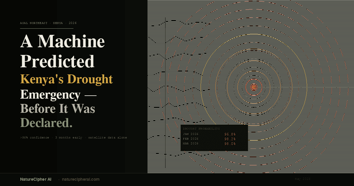
A machine learning model running on satellite climate data had already seen this coming, at greater than 96% confidence, for each of the three months January through March 2026 before the emergency was formally declared.
This article explains how that prediction was made, why the physics of groundwater makes it reliable, and what it means for communities whose survival depends on knowing what is coming before it arrives.
The Problem with Drought Early Warning
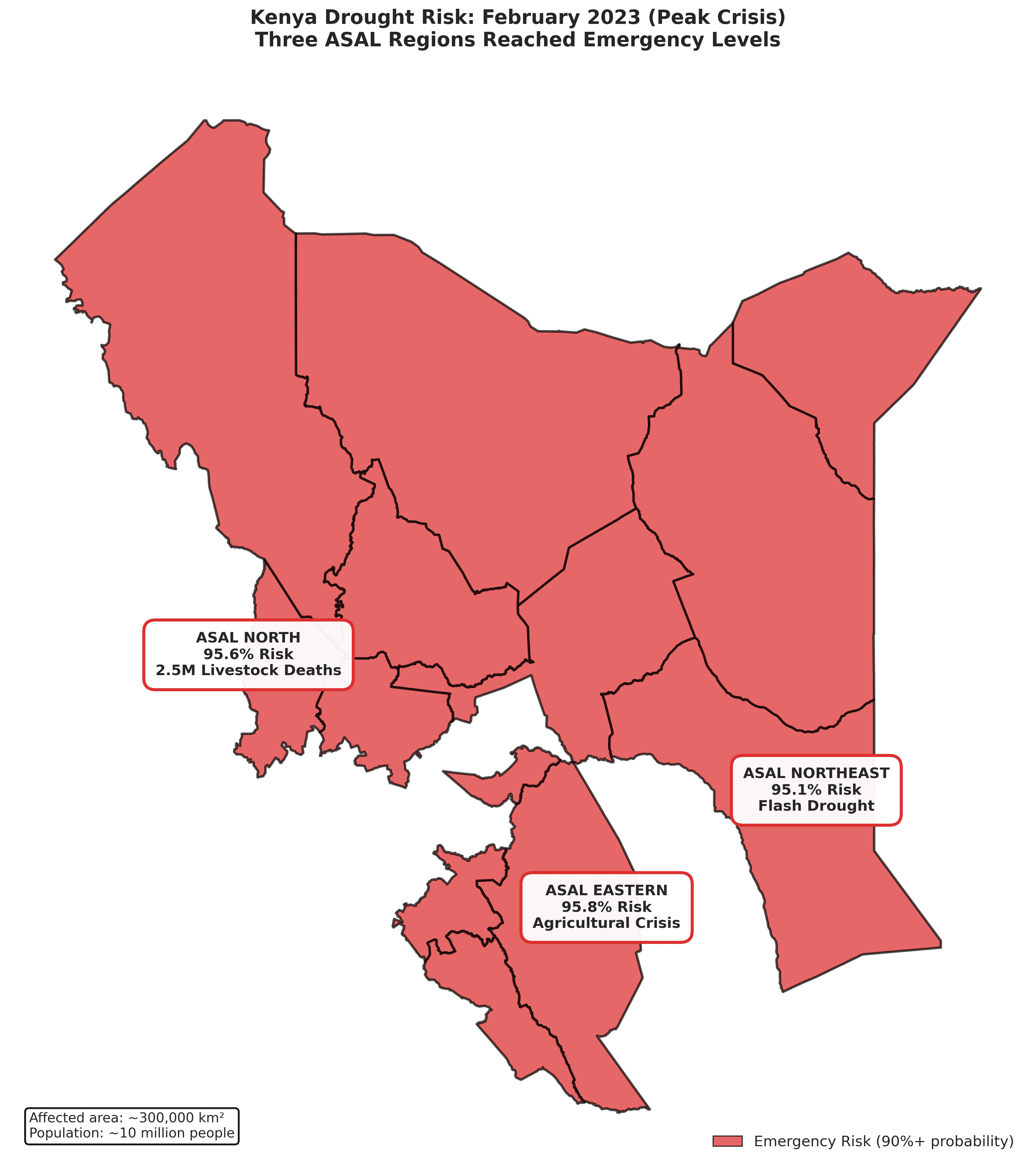
Kenya's Arid and Semi-Arid Lands (ASALs) cover roughly 80% of the country and are home to around 10 million people most of them pastoralists whose livelihoods depend entirely on rangeland and water availability. Drought in these regions is not an event. It is a slow-moving process that builds over months and years before it becomes visible in dying livestock and empty boreholes.
The challenge for early warning systems is that by the time a drought is observable in field reports, the window for effective intervention has already narrowed. Feed reserves, water trucking logistics, and livestock offtake programmes take weeks to mobilise. If a warning arrives only when the crisis is fully formed, it is already too late to prevent the worst outcomes. The Kenya Red Cross declared a drought emergency response for 2026 , but the question of how much earlier that mobilisation could have begun, with a reliable and quantified prediction in hand, is one the humanitarian system needs to grapple with.
The Cascade Bridge System
The model described here was developed as part of NatureCipher's Kenya ASAL drought prediction project. It works by reading the atmosphere and soil from space, then asking: based on everything the climate data is telling us, how probable is it that this region is in drought right now?
The system uses ERA5, a global climate reanalysis dataset produced by the European Centre for Medium-Range Weather Forecasts (ECMWF). ERA5 provides monthly estimates of precipitation, temperature, soil moisture at four depths, from 0–7 cm down to 100–289 cm — evapotranspiration, runoff, and atmospheric vapour pressure, all derived from a physics-based model constrained by satellite and ground observations. ERA5 data is available with approximately a two-month lag, making it usable for operational near-real-time forecasting.
The core innovation is a cascade bridge architecture. Because satellite vegetation indices (NDVI) and land surface temperature (LST) from MODIS are only available after 2001, the model cannot use them for earlier training data or for real-time inference. Instead, trained bridge models learn the statistical relationship between ERA5 variables and CHIRPS rainfall estimates, then between ERA5 and NDVI, then between ERA5 and LST. These bridges allow the system to reconstruct a full 51-feature climate picture from ERA5 alone — then pass that picture to the drought classifier.
The drought classifier is a decision tree trained on 35 years of climate data (1990–2025), which had earlier detected the 2022-2023 drought with a 95% accuracy, using a temporal block cross-validation design meaning it is always tested on future data it has never seen during training, preventing it from simply memorising historical patterns.
What the Model Predicted - And Had Already Got Right
For ASAL Northeast the counties of Garissa, Wajir, and Mandera the model produced the following drought probability estimates for the first quarter of 2026, generated from the data available in early 2026:
Month | Drought Probability |
January 2026 | 96.8% |
February 2026 | 98.2% |
March 2026 | 98.0% |
These are not marginal signals. A probability above 96% from a model calibrated across three and a half decades of climate history is an extremely confident call — comparable to a weather model predicting rain with near-certainty.
Critically, the model had already demonstrated its reliability for this exact region in the months immediately before the emergency. In November and December 2025, when drought conditions were intensifying and the Vegetation Condition Index was collapsing from 36.55 to 20.17, the model correctly identified both months as drought, with confidence above 91%.
The Groundwater Story the Numbers Tell
Drought probability alone, however compelling, is only part of the picture. The deeper question is: why is the northeast so stressed, and what does the physical state of the land tell us about what comes next?
To answer this, the same ERA5 dataset was used to compute a water balance recharge index, an estimate of how much rainfall each month actually enters the soil and contributes to groundwater storage, after subtracting evapotranspiration and surface runoff. This is not a direct measurement of groundwater, but it is a physically grounded proxy for whether aquifers are being refilled or drawn down, month by month.
The recharge record for ASAL Northeast, computed across 35 years of ERA5 data, tells a stark story.
The La Niña triple-dip drought of 2020–2022 , three consecutive years of suppressed Indian Ocean rainfall, was the worst drought sequence in four decades. In the recharge record, this shows clearly: 2022 was the single worst recharge year in 35 years of data, with a mean monthly anomaly of −11.8 standard deviations below the long-run climatological average. Boreholes that had served communities for years began to fail.
2023 brought partial recovery. The return of El Niño conditions produced an anomaly of +27.8 standard deviations, a powerful recharge pulse that refilled shallow soil layers. But this single good year could not restore what three years of deficit had removed from deep aquifer storage. Groundwater in these systems recovers on timescales of years to decades.
2025 returned to deficit, with a mean recharge anomaly of −3.9 standard deviations. The deep soil moisture layer — ERA5's estimate of moisture at 100–289 cm depth, the closest satellite proxy to aquifer conditions — declined throughout the year (annual change: −0.006 m³/m³).
By January–March 2026, the deep layer was still drawing down (monthly change: −0.002 m³/m³). The wells had not refilled. The aquifers were continuing to deplete. This is the physical mechanism that the model's high-confidence prediction reflects.
When Garissa received 3.81 mm of rain in January 2026, 69% below its already-modest average, it was falling on a landscape whose groundwater had been depleted for three years. The rainfall deficit was severe. But the groundwater deficit was worse, and it had been building since 2020.
What This Means for Early Warning
The recharge monitoring layer adds a dimension that pure drought probability cannot: it explains the physical reason for the model's confidence and gives water resource managers an independent, quantified signal. When the deep soil moisture layer has been declining for three years and the six-month cumulative recharge is far below normal, borehole managers, county governments, and humanitarian planners have a concrete basis for anticipating water point failure, not just a probability score from a model.
The IPC report of March 2026 documented the outcome: 3.3 million people in crisis, IPC Phase 5 in three county areas, children visibly malnourished, livestock dying. The model had flagged this, at above 96% confidence, three months before the report was published.
The technology exists. The data exists. The gap that remains is the connection between a machine's confident, early signal and the human decisions that depend on it. Closing that gap is what NatureCipher is built to do.