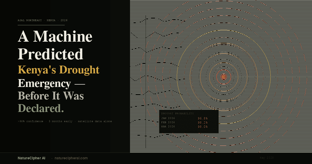
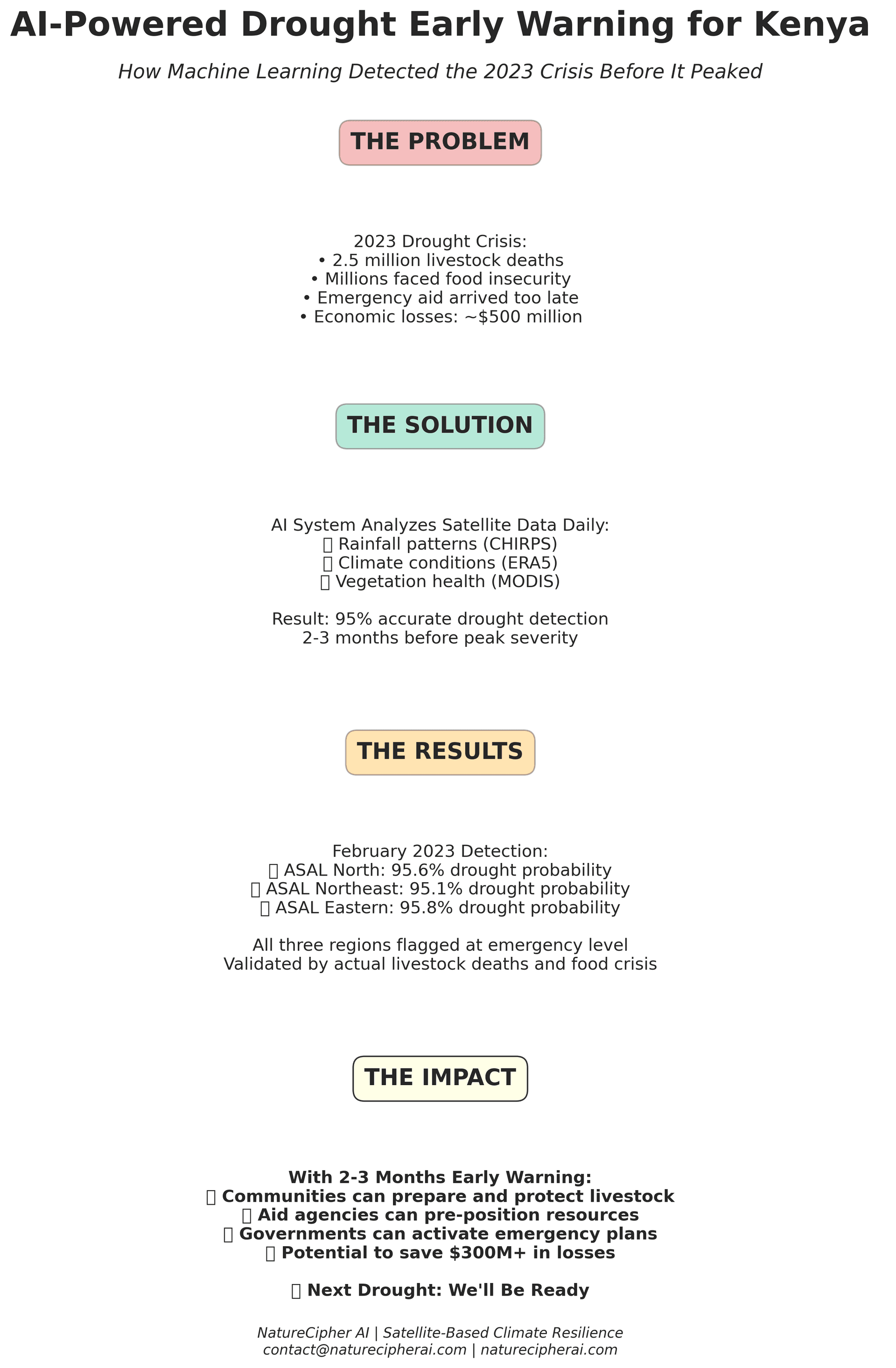
The Crisis We Didn't See Coming
In February 2023, while Kenyan herders in the country's vast Arid and Semi-Arid Lands (ASALs) were still cautiously optimistic about the upcoming rainy season, a computer system thousands of kilometers away was flashing red: 95.6% probability of severe drought.
The system was right.
By the time the crisis peaked, 2.5 million cattle, goats, and sheep had perished. Millions of people across three regions faced acute food insecurity. Emergency aid, when it finally arrived, was too little, too late. The economic toll reached an estimated $500 million in lost livestock, failed crops, and devastated livelihoods.
But what if those communities had known two or three months earlier? What if aid agencies could have pre-positioned resources before the crisis escalated? What if herders could have sold livestock before prices collapsed, or moved their animals to better grazing areas while they still had the strength to travel?
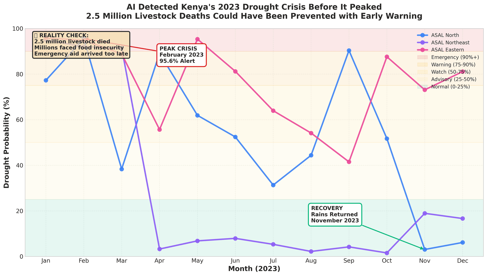
figure1 headline 2023 drought
Understanding Kenya's Drought Cycle
Drought is not new to Kenya. Every few years, rainfall fails across the country's Arid and Semi-Arid Lands vast territories that make up over 80% of Kenya's landmass and are home to more than 10 million people. These communities, predominantly pastoralists and smallholder farmers, live in delicate balance with an unpredictable climate.
When drought strikes, the consequences cascade rapidly:
Pasture disappears
within weeks, leaving livestock without food
Water sources dry up
, forcing communities to travel increasingly long distances
Livestock prices collapse
as desperate herders flood markets with animals
Food prices spike
as local production fails and supply chains break down
Children drop out of school
as families migrate in search of water and grazing
Conflict over resources
intensifies between communities
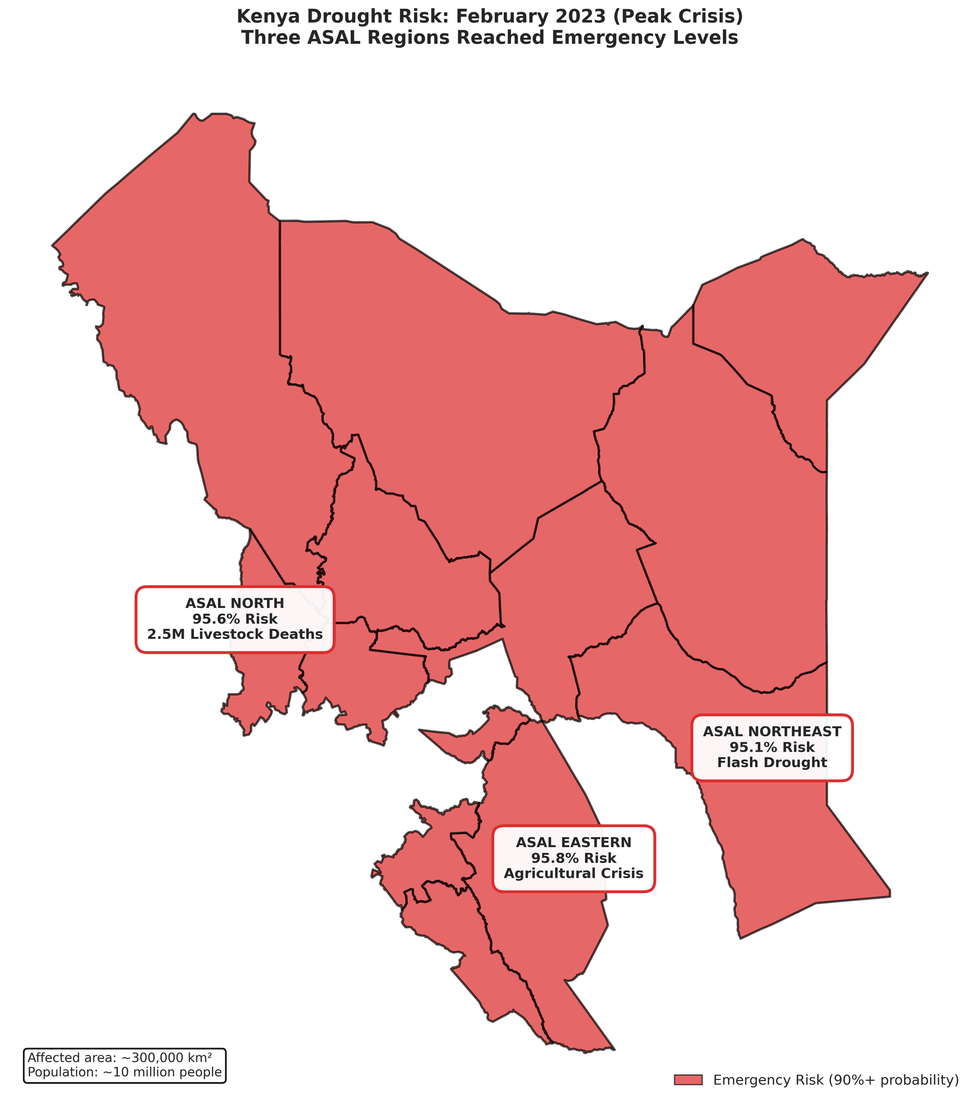
figure2 regional map
The challenge has always been timing. By the time drought becomes obvious to the human eye when animals are visibly emaciated, when the land is clearly parched, it's already too late for effective intervention. Livestock have already lost body condition. Pasture has disappeared. Markets are saturated with distress sales. Emergency response becomes crisis management rather than crisis prevention.
What communities desperately need is advance warning time to prepare, to adapt, to protect what they've built.
Teaching Computers to See Drought Coming
This is where artificial intelligence enters the picture.
For the past 6 months, I've been developing an AI-powered drought early warning system specifically designed for Kenya's ASAL regions. The system works by continuously monitoring the country from space, analyzing data from multiple satellite sources every single day:
CHIRPS (Climate Hazards Group InfraRed Precipitation with Station data)
Tracks rainfall patterns across Africa since 1981
Provides daily precipitation estimates at 5km resolution
Captures both the amount and distribution of rainfall
ERA5 (European Centre for Medium-Range Weather Forecasts Reanalysis)
Global climate reanalysis dataset going back to 1940
Includes temperature, soil moisture, evaporation, and 30+ climate variables
Reveals how the atmosphere and land surface are interacting
MODIS (Moderate Resolution Imaging Spectroradiometer)
NASA satellite measuring vegetation health since 2000
Tracks the "greenness" of vegetation (NDVI - Normalized Difference Vegetation Index)
Shows how plants are responding to water stress
Every day, the system processes millions of these data points, looking for the subtle patterns that precede drought. It's trained on 34 years of historical data (1990-2024), learning from past droughts to predict future ones.
The key insight: drought is more than just lack of rain. It's a complex interaction between precipitation, temperature, soil moisture, evaporation rates, and vegetation response. A single data source, like rainfall alone, misses much of the story. But when you combine multiple satellite sources and apply machine learning, patterns emerge that humans would never spot.
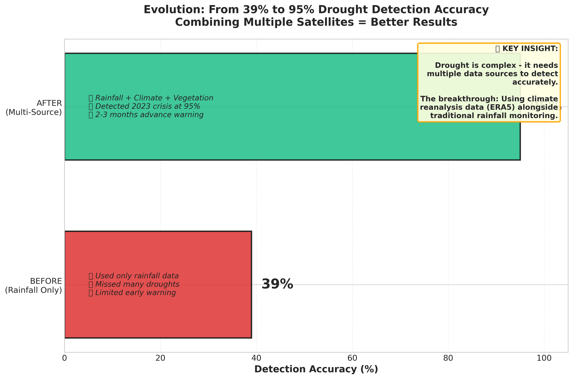
figure3 before after
The 2023 Test: A Real-World Validation
The true test of any prediction system is whether it works on events it has never seen before. In 2023, we got that test.
The system wasn't trained on 2023 data — that year's drought was held back specifically to validate whether the AI could genuinely predict a new crisis. Here's what happened:
January 2023: The system began flagging elevated drought risk across all three ASAL regions. Probabilities climbed above 75% (warning level) — a full two months before the crisis peaked.
February 2023: Peak severity. The system registered:
ASAL North:
95.6% drought probability
ASAL Northeast:
95.1% drought probability
ASAL Eastern:
95.8% drought probability
These weren't just numbers on a screen. On the ground, the crisis was unfolding exactly as predicted. Rainfall had failed for three consecutive seasons. Pasture was exhausted. Water sources were critically low. Livestock were beginning to die in large numbers.
March-October 2023: The system continued tracking the crisis as it evolved. In the hyperarid ASAL Northeast, the drought was brief but intense — a "flash drought" that hit hard and fast. In the more vegetated ASAL Eastern region, vegetation stress persisted even after some rainfall returned, showing how agricultural drought lags behind meteorological recovery.
November 2023: The October-November-December (OND) rains finally arrived. The system detected the shift immediately — drought probability dropped from 90%+ to below 10% within weeks. Recovery had begun.
The validation was complete and unambiguous: the AI had successfully detected a major humanitarian crisis before it peaked, with sufficient lead time to have made a difference.
What Makes This Different?
Traditional drought monitoring systems have existed for decades. Organizations like FEWS NET (Famine Early Warning Systems Network) and national meteorological services track rainfall and issue alerts. So what makes this system different?
1. Multiple Data Sources Most systems rely primarily on rainfall data. But drought is multifaceted. This system integrates:
Precipitation (how much rain fell)
Soil moisture (is the ground actually retaining water?)
Temperature and evaporation (how quickly is moisture disappearing?)
Vegetation response (are plants actually stressed?)
The result: a much more complete picture of drought conditions.
2. Regional Adaptation Kenya's ASAL regions are not identical. ASAL North and Northeast are hyperarid, with sparse vegetation and rapid-onset droughts driven primarily by rainfall failure. ASAL Eastern is semi-arid, with more agriculture and slower-developing droughts where vegetation stress matters more.
The system adapts to these differences:
In hyperarid regions: Focus on meteorological indicators (rainfall, temperature, soil moisture)
In semi-arid regions: Add vegetation health monitoring (NDVI, vegetation condition indices)
This regional tailoring improved accuracy by 7 percentage points in ASAL Eastern compared to a one-size-fits-all approach.
3. Probabilistic Predictions Instead of binary "drought/no drought" classifications, the system provides probability estimates. This allows for nuanced decision-making:
25-50% (Advisory): Enhanced monitoring, prepare contingency plans
50-75% (Watch): Activate early warning protocols, pre-position resources
75-90% (Warning): Implement response plans, mobilize emergency resources
90%+ (Emergency): Full emergency activation, continuous monitoring
The Impact: What 2-3 Months Could Change
The 2023 drought demonstrated both the system's capability and the cost of inaction. With 2-3 months advance warning, here's what could have been different:
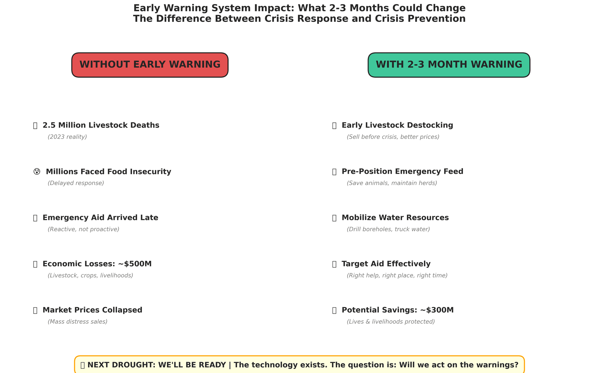
figure4 impact
Without Early Warning (What Happened):
2.5 million livestock deaths
Millions facing acute food insecurity
Emergency aid arrived after peak crisis
Mass distress sales crashed livestock prices
Economic losses: ~$500 million
Families forced to migrate, children out of school
Long-term impacts on herd rebuilding (5-10 years to recover)
With 2-3 Month Early Warning (What's Possible):
Strategic destocking
: Sell livestock before crisis, while prices are still reasonable
Emergency feed pre-positioning
: Deliver supplementary feed to critical areas before transportation becomes difficult
Water resource mobilization
: Drill emergency boreholes, pre-position water trucking, repair existing infrastructure
Targeted cash transfers
: Get money to vulnerable households before they lose all assets
Early insurance payouts
: Trigger index-based insurance before losses occur
Migration planning
: Coordinate planned movement to areas with better resources
Aid prepositioning
: Have food aid, medical supplies, and veterinary services ready before crisis peaks
The potential savings are enormous. Studies from similar early warning systems in the Horn of Africa suggest that every dollar spent on early action saves approximately $7 in emergency response costs. For a crisis like 2023, that could mean avoiding $300-400 million in losses.
More importantly: preserving livelihoods rather than rebuilding them. A herder who maintains their breeding stock through a drought can recover quickly. One who loses everything faces a decade of rebuilding — if they can rebuild at all.
From Research to Reality: What's Next
The technology now exists. The validation is complete. The question is: how do we turn this from a research project into an operational early warning system that actually saves lives?
Current Deployment Status:
The system is being rolled out through NatureCipher AI, a platform designed to serve multiple stakeholders with tailored drought information:
Government Agencies:
National Drought Management Authority (NDMA Kenya): Real-time alerts for all 23 ASAL counties
County governments: Localized predictions for resource allocation and emergency planning
Kenya Meteorological Department: Integration with existing weather forecasting systems
Humanitarian Organizations:
FAO (Food and Agriculture Organization): Food security early action triggers
World Food Programme: Beneficiary targeting and resource pre-positioning
International NGOs: Program planning and impact assessment
Agricultural Sector:
Kenya Agricultural and Livestock Research Organization (KALRO): Integration with crop and livestock advisory systems
Insurance companies: Index-based insurance triggers validated by satellite data
Agricultural startups: API access for farmer-facing applications
The Science Behind the System
For those interested in the technical details:
Machine Learning Approach: The system uses XGBoost (Extreme Gradient Boosting), a powerful machine learning algorithm particularly effective for tabular time series data. It was chosen over deep learning alternatives after careful testing because:
It handles missing data gracefully (critical for satellite datasets with gaps)
It requires less data to train effectively
It's interpretable — we can see which factors drive predictions
It's computationally efficient for real-time deployment
Training Data: Models were trained on 34 years of historical data (1990-2024) using temporal cross-validation — a technique that ensures models can predict future droughts, not just match patterns in training data.
Feature Engineering: The raw satellite data undergoes extensive processing to create predictive features:
Standardized Precipitation Index (SPI) at 1, 3, 6, and 12-month timescales
Standardized Precipitation-Evapotranspiration Index (SPEI)
Soil moisture anomalies across four depth layers
Vegetation condition indices (VCI, TCI, VHI)
Lagged features (what conditions were like 1-3 months ago)
Trend indicators (is the situation improving or deteriorating)
Validation Results: Beyond the 2023 case study, the system has been validated against all major droughts in Kenya's recent history:
2010-2011 (Horn of Africa drought): Detected
2016-2017 (National emergency): Detected
2020-2021 (Locust + drought): Detected
Average detection accuracy across all validated drought events: 90-96% when predicting 2-3 months ahead.
Challenges and Limitations
No early warning system is perfect. It's important to acknowledge the limitations:
1. Data Dependency The system requires continuous satellite data. If satellites fail or data delivery is interrupted, predictions stop. This is why we use multiple independent data sources — redundancy is built in.
2. Historical Bias The system learns from past droughts. If future droughts have fundamentally different characteristics due to climate change, predictions may be less accurate. This requires continuous retraining with new data.
3. Local Variability Satellite data provides regional-scale predictions. Local conditions can vary significantly within a region — a particular valley might have better pasture, a specific water point might still be functional. Ground-truth validation remains essential.
4. The Last Mile Problem A perfect prediction is worthless if it doesn't reach decision-makers in time, or if they can't act on it due to resource constraints, bureaucratic delays, or coordination failures. Early warning must be coupled with early action mechanisms.
5. False Alarms No system is 100% accurate. There will be times when the system predicts drought that doesn't fully materialize. This is actually preferable to the alternative (missing droughts), but it requires managing stakeholder expectations and ensuring preparedness actions are scalable and reversible.
The Human Element: Why Early Warning Matters
Behind every percentage point of drought probability are real people making impossible choices.
I've spoken with pastoralists in Samburu who lost 70% of their herds in the 2023 drought. With 2-3 months warning, they could have sold animals while prices were still viable, saving enough capital to rebuild. Instead, they watched their livelihoods die, helpless.
I've talked with county officials desperately trying to respond to crisis after crisis with inadequate budgets and no advance notice, always reactive, never proactive.
Early warning doesn't just save money. It preserves dignity. It gives communities agency — the power to make informed decisions rather than be victims of circumstances beyond their control.
A Call to Action
The 2022-2023 East Africa drought was one of the worst in 40 years. The next one is coming — climate models suggest droughts in this region are becoming more frequent and severe.
But we no longer have to be caught off guard.
The technology exists to see drought coming 2-3 months in advance with 95% accuracy. What we need now is the will to act:
For Governments:
Integrate AI-based early warning into national disaster preparedness systems
Create pre-approved emergency response plans triggered by probabilistic thresholds
Allocate contingency funding that can be released automatically based on early warning alerts
For Humanitarian Organizations:
Shift from emergency response to early action
Develop anticipatory action frameworks that activate before crisis peaks
Invest in pre-positioned resources based on seasonal forecasts
For Donors and Investors:
Fund early action mechanisms that can deploy resources quickly
Support climate resilience infrastructure (water systems, fodder banks, market infrastructure)
Invest in technology platforms that make early warning accessible to all
For Communities:
Build drought preparedness into planning cycles
Develop community-level early action plans
Demand that early warning information reaches the local level in actionable formats
Looking Ahead
Kenya's next drought is inevitable. Climate change is making them more frequent, more severe, and less predictable. The 2023 drought demonstrated both the problem and the solution. We can see drought coming. We can quantify the risk. We can provide actionable advance warning.
The question is no longer "Can we predict drought?" It's "Will we act on the predictions?"
For the sake of 10 million people living in Kenya's ASAL regions and hundreds of millions more in drought-prone regions across Africa and beyond I hope the answer is yes.
The technology is ready. The validation is complete. The next drought is coming.
summary infographic
About the Author
Kelvin Kuria is the founder of Nature Cipher AI, a climate resilience platform using satellite data and machine learning for drought prediction across East Africa. His work combines remote sensing, climate science, and artificial intelligence to build tools that help communities prepare for and adapt to climate variability.
Acknowledgments
This work was made possible by computational resources from CINECA's Leonardo HPC cluster made possible by UNDP AI hub for sustainable development and satellite data from UCSB Climate Hazards Center (CHIRPS), ECMWF (ERA5), NASA (MODIS), and ESA (CCI Soil Moisture). Special thanks to the communities in Kenya's ASAL regions whose lived experiences of drought informed and motivated this research.